Introduction of Mount Trusmadi
![]()
About Mount Trus Madi
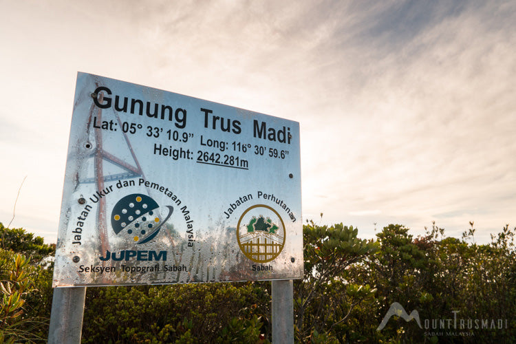
Standing at 2,642 metres (8,668 feet) above sea level, Mount Trus Madi is the second tallest mountain in Sabah and Malaysia after Mount Kinabalu. It is a forest reserve located in the Crocker Range National Park with an area of 184,527 hectares in total. The mountain is about 70 kilometres southeast of Kota Kinabalu, and it is surrounded by Ranau to the north, Tambunan to the west, Sook to the east, and Keningau to the south.There are five different types of vegetation in the area, including lowland mixed dipterocarps, hill mixed dipterocarp forest, lower montane forest, upper montane forest, and summit shrub. In total, there are 600 species of flora from 160 different families of plants. However, the most prominent species is arguably the Nepenthes x trusmadiensis, a species of pitcher plant endemic to Mount Trus Madi.
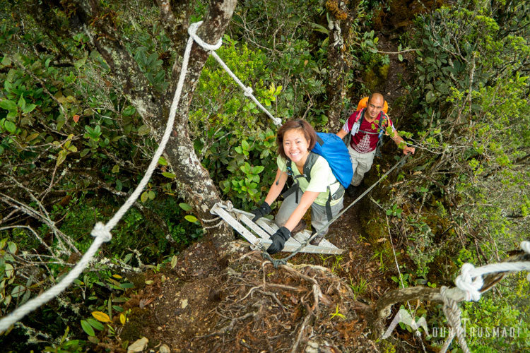
Many say that Mount Trus Madi is more challenging than Mount Kinabalu. Trus Madi is more undeveloped and remote, which translates to tougher trails as compared to Mount Kinabalu’s well-maintained trail. Hence, anyone who wants to experience a more challenging climb, Mount Trus Madi is a perfect choice.
SUMMIT TRAILS
There are three different trails (called ‘wayaan’ in local dialect) that climbers can opt for when they are planning to climb the mountain.
2D1N
Tambunan (Wayaan Kaingaran)
- Approximately 2.5 Hours from Kota Kinabalu City
- Length of Trail: 4.9km
-
Accommodation:
— Walai Tingkoyodon Resthouse accommodates upto 20 pax
— Electricity, pantry, toilet, and water supply are available - Oldest and most developed trail
- Easiest to climb due to consistent trail upgrades.
- Trail consists of bird trails and a 3km boardwalk from the starting point with toilets along the way
Of all the trails to Trus Madi’s peak, Wayaan Kaingaran is the most popular one and more tourist-friendly. The total length of the trail is 4.9 kilometres with a resthouse in the middle where you can rest before continuing the next morning. In fact, Wayaan Kaingara is the only trail that has a proper rest house—you would have to camp if you went on the other two paths.
To go to Wayaan Kaingaran, you would have to take a 4WD from Tambunan for about 2 hours and 30 minutes. Then, you would have to continue your journey for 2 hours on a wooden walkway to the resthouse. The hike resumes the next morning where you would have to go on a 4-hours trek before reaching the peak.
3D2N
Apin Apin, Keningau (Wayaan Mastan)
- Approximately 2 to 3 Hours from Keningau Town
- Length of Trail: 4.3km
-
Accommodation:
— Apin Apin Base Camp provides basic necessities
— Tents will be provided by climb operator - One of the least developed of the three trails
- The most challenging of the three trails as it is considered the steepest
At 4.3 kilometres, Wayaan Mastan is the shortest trail that you can take. However, it is more challenging than Wayaan Kaingaran because it is also the steepest compared to the other two trails.
The journey starts at Keningau, where you would have to drive your 4WD for about 2 to 3 hours to the starting point. Once you reach there, you will rest at the camp site before continuing your journey again at 11 pm.
4D3N
Sinua, Sook (Wayaan Mannan)
- Approximately 4 Hours from Keningau Town
- Length of Trail: 11.3km
-
Accommodation:
— Base Camp (Camp 1) and Camp 2 accommodate up to 30 pax
— Basic necessities such as running water and toilet are available - Longest of the three trails to complete
- Steep accents and cooler climate due to its higher altitude
- Trails known for rich biological diversity such as exotic rare plants, pitcher plants, orchids, and birds
Wayaan Mannan will take you the longest time to complete, which is three days in total. At 11.3 kilometres, it is also the longest of all the three trails. But the good news is that you would not have to get a 4WD because the road from Keningau to the starting point at Kampung Sinua in Sook is in good condition.
Differences Between
Mount Kinabalu and Mount Trus Madi
![]()
Difficulty
In general, Mount Trus Madi poses a more significant challenge compared to Mount Kinabalu. What makes Mount Kinabalu challenging is the altitude, which some climbers might find difficult to acclimatise. Besides that, the stairs can mean sore legs for the climbers.
However, climbers for Trus Madi would need to be a whole lot fitter than the average Mount Kinabalu climbers. With its muddy and slippery trails, Trus Madi are pretty much undeveloped and remote. Climbers would need to have good upper body strength because there are some parts where they have to go on a 80°-90° vertical climb.
Accommodation
On Mount Kinabalu, there are rest houses for climbers to get proper rest before continuing their journey to the summit the next day. The facilities and the food are well taken care, and it is the most comfortable that any climbers can get on a mountain hike.
On the other hand, rest houses are non-existent in two of the three trails on Mount Trusmadi. Climbers will have to stay pretty much out in the wilderness in the designated camping area. And the rest house at Wayaan Kaingaran is pretty basic, just enough to provide climbers with the essential needs.
Number of Climbers
There are 165 climbing permits allocated for Mount Kinabalu. That means that the mountain can get quite crowded during peak season. In contrast, fewer people climb Mount Trus Madi as each trail only allows a maximum of 20 to 30 pax per day.
Weather and Temperature
Both mountains have pretty much the same weather as the whole of Sabah, where the rain can be unpredictable. In general, however, Mount Kinabalu is colder, with a temperature that can go down as low as 0°C. On the flip side, Mount Trus Madi is warmer, with a temperature around 11°C to 19°C. So, you will not have to wear as many layers of clothings if you go to Mount Trus Madi.